Search This Blog

Saturday, 19 September 2020

Climbing Scafell Pike


scafell pike map

Scafell Pike route


Our last hike for this year was to Scafell Pike. That was on the 29th of August after our walks in Langdale Pike and to see the highest waterfall in the lake district, Scale Force. Shania, our elder daughter, left the lake district by train to go  home to fill out her university application forms and work on her budding fashion business. We were sad because only three of us were left to hike the highest mountain in England. The height of the Scafell pike is 978 meters. It's about 3209 feet and even though it doesn't look that high, one shouldn't underestimate the long winding climb to the summit.


It was supposed to take 3 hours to climb and a similar time to descend. But Ines and our younger daughter Shakyra had a slightly different idea, and revealed it to me only on the last day. The usual hike from Wasdale to the scafell and back is about 9 kilometers, but Shakyra wanted to take the longer route and climb down from the other side of the Scafell Pike, which meant there were another two mountains to hike - the total length was around 11 kilometers.

The surprise did not end there. I realised there were another 2 summits to climb on our way. That's Shakyra's great idea. The first one was Broad craig, which is 931 meters high (3055'), and the second one was Great End, which is 910 meters high (2955'). (Please see the maps). 

We travelled to Wasdalean, and the car park was already full. Luckily we found a place to park by the gate. However there were many cars behind us and they all had to turn back.

When we started the climb, there were no people walking with us, as you can see from the pictures. But half way through the ascent we realised we had made a mistake. There were many people climbing as well as descending from the summit already. We had to stop each time there was a narrow passage to avoid clusters of people because of the Covid-19 virus. But I realised some people simply ignored that. Sometimes we had to move completely out of the way from the normal route because people were climbing up or coming down in groups. At that point there was no way back either. 


When we reached the summit, in that small space where the last 2 meters to get up were, there were so many people crammed into those 4 square meters that we completely avoided it. Therefore I may not have hiked all the 978 meters, but only 976 meters.

Maybe this is one of the reasons that the UK government was forced to declare the 6 person rule - because people simply ignore the 'safe distance' rules. 

So, we climbed up to the Scafell pike and soon realised that there was very very cold wind that was difficult to bear. Summit was widely open to the strong wind from Irish sea and, boy it was cold evan in a summer day. We sat inside a small area where kind hearted climbers built small walled area with stones. There were three or four structures like that around the summit head.

But it is still cold and I realised Shakyra and I was shivering while Ines was insisting that we should move quickly. But Shakyra took her time to eat her sandwich slowly like she was sitting in the house in front of the TV. Well, she was quick to climb up and down and I am the one who was walking slowly. I was worried about my knee.

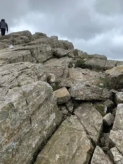
To climb down from otherside of the scafell towards Broad Crag was really difficult and steep. Someone already cautioned me about this. Apparently on the other side of the ridge there were few deaths few years back. They mistook the descent route and ended up in the most steeped part of the mountain.
I saw Ines slipped and fell down when we were hiking towards the Broad Crag. There was no way I could help her. I was struggling myself few feets away .Two ladies rushed towards her to help. But Ines got up at no time and moved on.

Climbing to Broad crag was difficult but once there it was amazing. It's partly because naturally created stone wall shielded the climbers from cold wind and one can rest there, while enjoying the beauty of the nature presented to the eyes. I wanted to stay there for a while but very few people were going on in this route so Ines wanted to hurry up. Also there was no proper route as such. You have to negotiate through the heavy boulders surrounding the mountainside. Then we went half way up to Great End where height stands from sea level at 910 meters. We turned to right there and then to an easy descent. When you turn left to get the final part of the journey I could see the beautiful lake called 'Spinking Tam' below.

Descent onwards was not that difficult but very long and tiring. But in the end, after long eight hours we made it.

Video:


No comments:

Post a Comment

I encourage you to share your thoughts if they are related to the topic being discussed. I review all the comments being posted. The views expressed in comments reflect those of the author and do not necessarily reflect my opinion.
I want to publish all your comments, but I expect comments generally to be courteous. I will not post comments if they:
contain hate speech directed at any particular race, color, sex, sexual orientation, national origin, ethnicity, age, religion, or disability;
contain obscene, indecent, or profane language;
contain threats or defamatory statements;
promote or endorse services or products of yours. (Non-commercial links that are relevant to the topic or another comment are acceptable for posting.)
Thanks